It's Like a Jungle Gym: Hiking Beehive Trail in Acadia National Park
- Steve
- Jun 1, 2023
- 6 min read
We visited Acadia National Park in late June when the temperatures were warming, rain wasn’t in the forecast and crowds hadn’t arrived yet. It was the perfect time and the weather cooperated with no rainy days. In addition to Beehive Loop we were able to complete three other walk/hikes including the Ocean Path, Cadillac Mt, and Bubble Loop.
Acadia National Park
Acadia National Park is a stunning natural area located on the coast of Maine that includes about half of Mount Desert Island, part of the Isle au Haut, the tip of the Schoodic Peninsula, and portions of sixteen smaller outlying islands. It’s known for its dramatic Atlantic coastline, granite peaks, dense forests, and pristine lakes.

The history of Acadia before it became a national park is really rich—it stretches from ancient Indigenous peoples to French settlers and American philanthropists. The Wabanaki people, who inhabited the area called Acadia for at least 12,000 years called Mount Desert Island 'Pemetic' meaning 'range of mountains'. They lived seasonally, traveling between the island and inland areas for fishing, hunting, and gathering.
By the mid-to-late 1800s, Acadia became a popular destination for wealthy visitors from cities like Boston, New York, and Philadelphia. These were known as “Rusticators”—people who came to experience nature but lived in luxury. Famous families like the Rockefellers, Morgans, Fords, and Vanderbilts built massive mansions they referred to as their 'summer cottages'.

Concerned about the preservation of the area, locals and summer residents, led by figures like George B. Dorr and Charles W. Eliot, began buying up land to protect it from development. Many credit Eliot with the idea of transforming these lands into a national park. With the Help of Dorr who would become known as the 'Father of Acadia National Park', these two men advocated fiercely at the state and federal level.

Their efforts paid off. On July 8, 1916 President Woodrow Wilson established its federal status as Sieur de Monts National Monument. In 1919, it became Lafayette National Park, the first national park east of the Mississippi. In 1929, it was renamed Acadia National Park to honor the region’s early French heritage. It was the first national park created from private lands gifted to the public.
Hiking Beehive Trail In Acadia
To be honest, we had hoped to climb Precipice Trail during our visit to Acadia, but when we pulled into the trailhead parking lot, we were greeted with these signs.


Luckily, we had an alternative plan to hike Beehive Loop, which was just a short distance away. This is the view from the parking lot of our destination, the Beehive. The small mountain or hill is only 518 feet tall but each foot you climb brings a new challenge. Manufactured steps, iron rungs, ladders, and handrails will help you make your way up the summit. While all of the obstacles are reasonable, there is a fair amount of scrambling and the exposure in some sections can be intimidating. If you look closely, you can spot people climbing on the narrow ledges. Know your own limitations and risk tolerance before considering this hike.

Start on the Bowl Trail
The hike starts on the Bowl Trail that winds through a forested area at the base of Beehive. The lack of a crowd at the start of the trail was a good sign since Beehive is a less than ideal experience at busy times. With even a small crowd, the hike can come to a complete standstill and waiting in line to climb the more challenging sections of the trail is not my idea of fun.

Approximately a quarter mile in, a large cairn marks the junction where the Bowl Trails intersects with the Beehive Trail. Historical records show that the Beehive Trail has been around since 1874 but the current version dates to 1916. The route was laid out by Rudolph Brunnow who served as Committee Chairman of the Bar Harbor Village Improvement Association from 1912-1917. The area is famous for having some of the most challenging trails in the National Park, including the Precipice and Beehive.

Start the Climb on the Beehive Trail
This sign marks the entrance to the Beehive Trail and Dave took his time reading and rereading the warning. I’m sure more than a few National Park lawyers were involved in drafting this language. There is no failure to warn with this hike.


Nothing unusual with these granite steps. I think it's set up this way to build a little bit of confidence before the tricky sections begin.

The granite steps are a hallmark of the Acadia trail system. These highly crafted steps were designed to blend in with the natural landscape.

Nothing too tricky but using the 'three points of contact' rule for rock scrambles means maintaining either two feet and one hand, or two hands and one foot, in contact with the rock at all times. This practice helps ensure stability and minimizes the risk of slips and falls.

Even early on, the Atlantic Ocean views from the trail were beautiful.

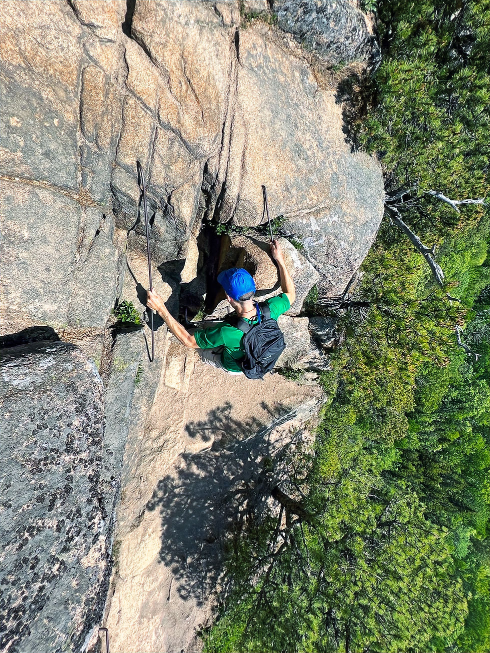
Time to ratch up the risk meter. Crossing the metal grate/ladder that spanned a large gap on the ledge required Dave to place significant trust in the crew responsible for maintaining the trail. After a few deep breaths he made it across. We didn't discuss whether this ladder was part of the original build from 1916.

It's strange that after crossing the metal ladder, walking on a narrow ledge with a steep drop on one side doesn't seem daunting anymore. Maybe it’s the calming nature of the ocean view.

Brunnow's highly crafted cliff trails used iron pins, rungs, rails, ladders, and bridges extensively in areas where near vertical climbs eliminated other climbing options.


The National Park Service states that on the Beehive Trail, many of the original iron rungs still exist in areas where the cliffs are relatively dry and not affected by freeze-thaw cycles. Other rungs and rails have been replaced with in kind iron work.

Time for a short break in the shade and on a relatively wide section of trail.

Less than 15 minutes after starting the trail, our risk tolerance had increased significantly. We no longer hesitated when facing an 18-inch wide step-up on the ledge. It's incredible how quickly you can adapt to the challenges.

But a short but narrow wooden bridge still created some anxiety. The trail essentially zigzags up the cliff, offering progressively better views of Sand Beach as you climb higher.

Focusing one step at a time, he successfully crossed.

A different perspective from another set of iron rungs. Dave captured these photos as I climbed the rungs.

Preventing the camera from crashing into the rock should earn me some extra style points.

More breathtaking views of the forest, Klef Pond and Gorham Mountain, with its rounded summit positioned at the top right of center.

Navigating some rather narrow exposed sections of the trail. Once again risk tolerance has shifted dramatically from when we started the hike.


And let's throw in another vertical climb that probably utilized iron rungs that have been in place for close to a century.
A well deserved rest and selfie.

A short and easy rock scramble and ....

... we found ourselves at the summit of the Beehive, standing 520 feet above sea level. It certainly felt as though we had climbed more than 500 feet, but then again, it was like climbing a jungle gym. The 0.3 mile trail to the summit took us just over 30 minutes.

Looking eastward from the summit, you can see the harbor islands with the Schoodic Peninsula in the distance.

Just beneath the summit are Sand Beach and Newport Cove.

Here's a brief geology observation: Over the past two to three million years, massive glaciers have moved across the state of Maine. They shaped the landscape by carving mountains through a process known as glacial abrasion. In this process, the glacier's base, filled with rock debris, scrapes and grinds against the mountain bedrock. Similar to sandpapering, this action wears down the bedrock, resulting in smoothed surfaces such as the summit of Beehive.

Follow The Beehive Trail to The Bowl
After enjoying the summit it was time to begin our descent. It's a short 0.3 mile descent to the Bowl, a small pond nestled behind the Beehive Mountain.


Return to the Trailhead on the Bowl Trail
After taking in the scenery, we proceeded along the Bowl Trail, which led us back to the trailhead parking area.

Make sure to stop at the junction of the Bowl Trail and Beehive Trail by the large rock cairn. It's a great spot to watch hikers climbing the Beehive. I've highlighted a few of the hikers.

Unwind on Sand Beach After the Hike
We decided to relax on Sand Beach after the hike and I highly recommend it, if you have time.


The cliffs rise right out of the ocean.

A good beach crowd for a warm, sunny afternoon in June.

Here's a final geology observation: This panoramic photo of the beach highlights how the Beehive (far right of center) is a classic example of a rouche moutonnée in geological terms.
Asymmetrical peaks (steep on one side and more gradual on the other) like the Beehive were formed by a process of glacial erosion known as 'glacial plucking.'

Plucking happens when a glacier slides across a mountain peak. The glacier smooths the northern side and the pressure of the overlying ice past the peak causes larger chunks of the southern side to break off. Geologists are able to look at the Beehive and determine the direction that glaciers were travelling, even though the glaciers disappeared from the region over 10,000 years ago. Once you’re familiar with the shape, you can spot these distinctive features elsewhere in Acadia.


Comments