Storm Clouds Over the Maynard Mine Trail in Indian Canyons
- Steve
- Nov 7, 2022
- 5 min read
Information about Aqua Caliente Tribe and Indian Canyon reservation
Since time immemorial, the Agua Caliente Band of Cahuilla Indians has called the Palm Springs area home. Archaeological research shows the ancestors of the Tribe have occupied these canyons for at least 8,000 years, mirroring the migration stories of the Agua Caliente people.

Initially, their territory covered approximately 2,400 square miles in Southern California. In ancient times, they established complex communities in the Palm, Murray, Andreas, Tahquitz, and Chino canyons, all benefiting from plentiful water sources. They gathered indigenous plants and seeds for sustenance, medicinal purposes, and crafting baskets, as well as cultivated crops such as melons, squash, beans, and corn.
As outsiders discovered the Coachella Valley's potential, the tribe found their ancestorial homelands disrupted. To encourage the railroad, the U.S. government subdivided the Palm Springs area into one-mile-square sections, granting the Indians every other section while the Southern Pacific Railroad emerged as the primary beneficiary of this land agreement. In 1876 and 1877, the U.S. Federal Government deeded in trust to the Agua Caliente people only 31,500 acres for their homeland. Approximately 6,700 acres of this total are situated within the city limits of Palm Springs. The remaining parcels are scattered across the desert and mountains in a checkerboard pattern, as illustrated in the map below.

While visitors see the Indian Canyons only as a hiking destination, for the Agua Caliente Band of Cahuilla Indians, it’s their ancestral home. From mountain-fed streams, lush palm groves, and seasonal waterfalls, the Indian Canyons has long been an oasis of natural beauty and resources, providing the Tribe with an abundance of raw materials to not only survive but to thrive.
Hiking the Maynard Mine Trail.
Hike distance: 5.95 miles
Elevation Gain: 2363 ft elevation gain.
TrailsNH Hiking Difficulty Calculator: 168 - Strenuous

Click here for a review of prominence and its role in mountain topography
Click here to navigate to the TrailsNH website for an description of the hiking difficulty calculator
The hike begins at the Andreas Canyon parking lot. Since there is no shade on this challenging trail, it's crucial to ensure you have enough water and sun protection. Even with the intense heat of the summer, dense vegetation surrounds Andreas Creek and the numerous springs near the trailhead.

Unlike the easier Andreas Canyon Loop and Murray Canyon Trail, the hike to Maynard Mine Trail is a classic desert climb…..straight up the side of the San Jacinto Mountains. The trail originally served as an access route for Jim Maynard's tungsten mine.

Fifteen minutes into the hike, the palms fade into memory and the steady climb begins.

Although the perennial shrubs and grasses were struggling without summer monsoons and fall rain storms, this gander cholla was thriving. The fleshy stems of the cholla serve as reservoirs, storing water when it’s available and releasing it during dry periods. In addition, they possess a broad and shallow root system that rapidly absorbs water from even light rains. These as well as other adaptations allow cacti to survive in one of the hottest and driest desert in North America.

Like most hikes in the San Jacinto Mountains, the Maynard Mine trail climbs rapidly with an average elevation gain on this trail of over 790 feet per mile which borders on very steep. Most sources classify a trail rise of 800 ft or more as very steep.

The steep base of the San Jacinto Mountains results from a combination of tectonic forces, erosion processes, and rock characteristics.

The mountains are located in a seismically active area near the San Andreas and San Jacinto Fault Zones. Movement along the faults have led to rapid uplift and steep scarps. The steep grade is further enhanced by sparse vegetation that fails to shield the rock from erosion caused by from occasional heavy rains and flash floods.

Many of the rocks are metamorphic schist and gneiss that are quite resistant to weathering. This resistance means that, even as erosion occurs, the rock maintains its rugged profile.

After hiking about 1.5 miles, we reached a plateau and enjoyed a brief break from the uphill march. To the east, Murray Peak (left of center) rises prominently in the foothills above Palm Springs.

To the west, a cloud bank was forming over the San Jacinto Mountains.

The plateau vanished all too swiftly, and the ascent began again. At this point we had hiked about 1.75 miles and gained almost 1500 feet in elevation.

Although there was no rain in the forecast when we began our hike, it was not a good sign that the clouds were gradually descending over the peaks and moving toward the valley floor.

Along this section of the trail, the thick-leaved Yerba Santa shrubs were more noticeable. This drought tolerant evergreen shrub flourishes in dry, rocky soils. It features long, thick, leathery green leaves covered with a sticky resin. Traditionally, Indigenous peoples have valued this plant for its medicinal properties, using it as a remedy for respiratory problems and to treat sores on people and animals.

Fun fact, if you are in the 'correct age' bracket, crushing the leaves and rolling them between your finger gives off the smell of Bazooka Gum. This iconic brand of bubble gum was introduced in 1947 and is still marketed throughout the world.

No rest for the weary.

After covering 2.5 miles, we had ascended 1800 feet and reached the trail's high-point at 2640 feet. This view of the San Jacinto peaks was worth the effort.

To reach the mine we had to follow the trail downhill for half a mile and....

... descending 300 feet in elevation.

This section of the trail has several sharp switchbacks that are partially eroded, marking a significant change from the previously steep but stable footing of the uphill climb.

The mountains and clouds add a dramatic touch to the photos. To Dave's left is the green belt of vegetation fed `by the Murray Canyon Creek.

After descending from the high-point, the trail follows the top of a ridge separating Andreas Canyon and Murray Canyon.

Follow the sign to the remains of the mining operation.

A rock in the mine area features a plaque dedicated to Jim Maynard. Jim was a prominent Palm Springs resident, a local legend, trail guide, climbing expert, and founder of the area’s first search-and-rescue group. Among his many projects, Jim operated this tungsten mine during the 1940s. He personally transported extracted rock containing tungsten down the mountain using a wheelbarrow. However, specific records detailing the mine’s productivity, profitability, or overall success are scarce. The limited available information suggests that while Maynard’s mining operations were notable, they may not have achieved significant commercial success.

Time to take a photo and capture the moment,

The rock piles are all that remain of the mine at the end of the trail. However, it is reported that you can continue beyond this point and descend to the entrance of one of Maynard’s other tungsten mines.

Faced with threatening clouds, we opted for a quick lunch and chose not to continue exploring. Our goal was to return to the trailhead before any potential rain started.

Even though we were moving quickly, we paused to appreciate the Engelmann hedgehog cactus, also called the Strawberry cactus. Typically, Engelmann's hedgehog cactus grows in clusters, sometimes with 20 or more stems reaching heights of 4-12 inches. Their vibrant magenta flowers bloom in April, and if pollinated, they develop into fruit. The fruit tastes similar to strawberries and is consumed by birds, rodents, and people, if you manage to get to them before the birds do.

There's no shortage of amazing views on the hike back to the trailhead.

It wasn't raining in our location, but it definitely was at higher elevations.


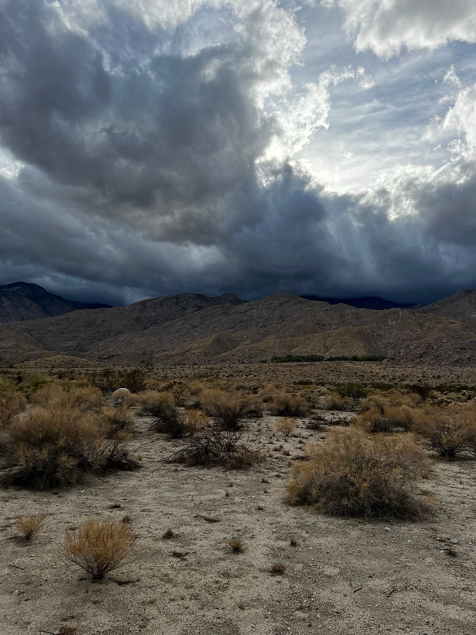
The trailhead appeared to be the battleground where the blue skies of the valley clashed with the dark, overcast clouds spilling over the mountains.

Another amazing hike in Indian Canyon. Here is the satellite view of our hike.

Throughout all our years of hiking in the Coachella Valley, these might be the most impressive cloudy skies we've encountered.
Following the hike, it was time to enjoy a cold mojito at Chill Bar in Palm Springs.

コメント