Switchbacks, Ridges, and Ropes: Climbing Mt Storm King, WA
- Steve
- Oct 16, 2022
- 4 min read
After a relaxing hike on the Hoh River Trail yesterday, we were ready for a more adventurous hike and Mt Storm King more than met our expectations.
Hike distance: 5.09 miles
Elevation Gain: 2,292 ft elevation gain.
TrailsNH Hiking Difficulty Calculator: 153: Strenuous

TrailsNH Hiking Difficulty Calculator
The TrailsNH Hiking Difficulty Calculator provides an idea of the challenge a hike might present. Its purpose is to assist you in deciding whether a hike is manageable for you or if it's too demanding.
Follow this link to visit the TrailsNH website and read about the hiking difficulty calculator.
Side trip to Marymere Falls
From the parking lot we followed the Marymere Falls trail for about a 0.5 miles through a forested area.


We had some company.

At a trail junction we decided to start the day off with a short hike to Marymere Falls. The trail navigates through old growth forest and ends at a 90-foot waterfall. It's the most popular day hike at Lake Crescent.

After a brief stop, we headed back to trail junction to join the Storm King trail.

A giant Western Red cedar stood guard over the trail.

Switchbacks
The trail's 'easy' section ended immediately when the switchbacks started.

We quickly understood why the trail is classified as strenuous using the TrailsNH Hiking Difficulty Calculator; the elevation gain on this hike is a killer.

Although we were hiking through dense forest, every once in a while we had a peek-a-boo view of the Olympic Mountains.

The steep terrain didn't stop these giant Douglas firs from firmly rooting themselves into the hillside.

There were moments when we wondered when we'd get a break from the switchbacks which now included rocky and slippery surfaces.

Finally, after climbing 1.25 miles and gaining more than 1300 feet in elevation, we reached the Crescent Lake viewpoint and had a break from the switchbacks. It was around this time Dave realized the next section would involved ridges and ropes.

One last series of switchback spread over 0.2 miles and ....

... we reached the end of the maintained trail. It’s decision time! Consider your own comfort with these types of trail conditions and make sure the surfaces are dry from any recent rains.

Ridges: Decision Point #1
This section of trail is unmaintained and quite exposed. There are steep climbs with sharp drop-offs.

Make sure you're comfortable with this exposure since you'll need to return using this same section of trail. If you're uncertain, it's best to start early in the morning before the trail becomes crowded, which will further increase any anxiety about the ridges.


Ropes and More Ridges: Decision Point #2
You've reached the rope section when you're greeted with a pile of used gloves to help grip the rope as you climb. Ideally, we should have purchased a few pairs of gloves before starting the hike, but we only considered this after we finished the hike.

The ropes that lead to the top are not installed or maintained by the land manager, so be aware that using them is at your own risk. There are six steeply inclined rope sections covered in loose sand, offering minimal traction. We are biased and would never complete this hike without using good hiking boots that offer some traction in these conditions. With a little bit of hesitation, we put on our gloves and began climbing.

Once again, make sure you're comfortable before starting the climb. This part of the trail can become congested, but we arrived early and had most of the rope sections to ourselves. Remember, don't climb up anything you wouldn't want to climb down.

A sense of relief after finishing the initial ropes.

Each rope section presents its own challenges. These photos do not capture the trail's true steepness.

After the last rope, the trail continues to a rocky outcropping. It's an easy climb that appears more challenging than it truly is.

The trail continues along a narrow fin with sharp drops on either side. At the end of the slow walk across the fin, you're rewarded with breathtaking views of Crescent Lake and the Olympic Mountains...

... but Weston decided to take it a step further and take a seat on the rocky edge with a view of the lake, so Dave followed him.

Time to relax and take in the views.
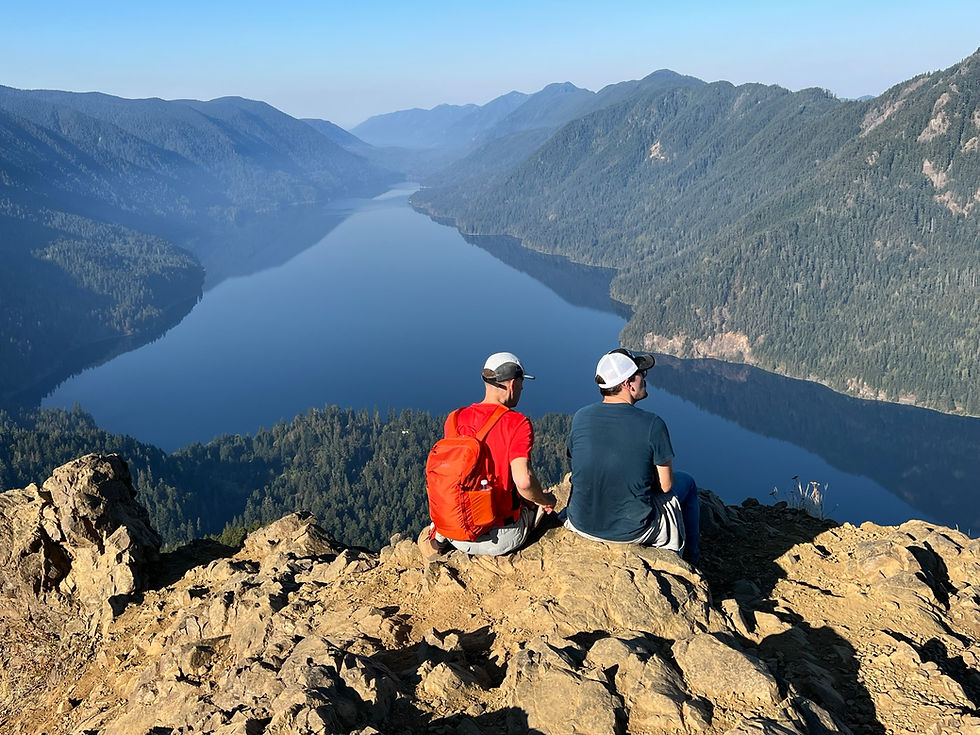

Despite the wildfires in the area, the views were excellent. By arriving at the viewpoint early in the day, we avoided the smokier conditions. In the morning, when temperatures are cooler, the winds are generally not strong, which helps keep the smoke confined to the area around the burn site.

On the way down, Dave led the way on the fin.

I decided to video my walk across the fin to capture the feeling on walking across this narrow ridge.
The rope sections on the descent are unavoidable. Opinions vary on whether these ropes present more of a challenge when going up or down. Personally, I find them more difficult on the way down. While climbing uphill, you have a clear view of the terrain and can plan your steps accordingly. In contrast, descending can be trickier due to potentially limited visibility of the terrain.

After just over an hour, we arrive back at the start of the maintained trail.


We spent about 4 .5 hours on the hike from beginning to end. It was a relatively quick hike since we needed to drive back to Tacoma this afternoon. It was a fantastic way to conclude our adventures in Olympic National Park.

Below is the AllTrails map for Mt Storm King. The extra mileage we reported was due to the addition of the Marymere Fall hike.

Comments